WHAT TYPES OF PARKS QUALIFY FOR THE VK5 PARKS AWARD?
Only South Australian National Parks & South Australian Conservation Parks qualify for the Award.
There are a total off 22 National Parks and 277 Conservation Parks in South Australia.
These parks are under the control of the Department of Environment, Water and Natural Resources (DEWNR).
A NATIONAL Park is 'land that is of national significance by reason of its wildlife or natural features'.
A CONSERVATION Park is 'land that is protected or preserved for conserving wildlife or natural or historic features'.
WHAT TYPES OF PARKS DO NOT QUALIFY ?
The following types of South Australian Parks do NOT qualify for the Award.
o Game Reserves (GR)
o Recreation Parks (RP)
o Regional Reserves (RR)
o Wilderness Protection Area (WPA)
o Conservation Reserves (CR)
o Marine Parks (MP)
o Recreation Parks (RP)
o Regional Reserves (RR)
o Wilderness Protection Area (WPA)
o Conservation Reserves (CR)
o Marine Parks (MP)
WHERE ARE THE PARKS LOCATED?
The 22 National Parks and 276 Conservation Parks are spread across South Australia. They are under the control of the Department of Environment, Water and Natural Resources (DEWNR).
A LIST OF QUALIFYING PARKS
NATIONAL PARKS (total of 24)
- Adelaide International Bird Sanctuary-Winaityinaityi 5NP-022
- Belair, 5NP-001
- Canunda, 5NP-002
- Coffin Bay, 5NP-003
- Coorong, 5NP-005
- Flinders Chase, 5NP-006
- Gawler Ranges, 5NP-008
- Glenthorne-Ityamaiitpinna Yarta National Park
- Great Australian Bight Marine, 5NP-009
- Ikara-Flinders Ranges, 5NP-007
- Innes, 5NP-010
- Kati Thanda-Lake Eyre, 5NP-011
- Lake Gairdner, 5NP-012
- Lake Torrens, 5NP-013
- Lincoln, 5NP-014
- Malkumba-Coongie Lakes, 5NP-004
- Mount Remarkable, 5NP-015
- Murray River, 5NP-016
- Naracoorte Caves, 5NP-017
- Nilpena Ediacara National Park 5NP-024
- Nullabor, 5NP-018
- Onkaparinga River, 5NP-019
- Vulkathunha-Gammon Ranges, 5NP-020
- Witjira, 5NP-021
CONSERVATION PARKS (total of 278)
- Aberdour, 5CP-001
- Acraman Creek, 5CP-002
- Aldinga Scrub, 5CP-003
- Althorpe Islands, 5CP-004
- Angove, 5CP-005
- Avoid Bay Islands, 5CP-006
- Baird Bay Islands, 5CP-007
- Bakara, 5CP-008
- Bandon, 5CP-263
- Bangham, 5CP-009
- Barwell, 5CP-010
- Bascombe Well, 5CP-011
- Baudin, 5CP-012
- Baudin Rocks, 5CP-013
- Beachport, 5CP-014
- Beatrice Islet, 5CP-015
- Belt Hill, 5CP-016
- Beyeria, 5CP-017
- Big Heath, 5CP-018
- Billiatt, 5CP-019
- Bimbowrie, 5CP-020
- Bird Islands, 5CP-021
- Black Hill, 5CP-022
- Black Rock, 5CP-023
- Boondina, 5CP-024
- Brookfield, 5CP-025
- Bullock Hill, 5CP-265
- Busby Islet, 5CP-026
- Butcher Gap, 5CP-027
- Calectasia, 5CP-028
- Calpatanna Waterhole, 5CP-029
- Cap Island, 5CP-030
- Cape Blanche, 5CP-031
- Cape Gantheaume, 5CP-032
- Cape Willoughby, 5CP-033
- Caralue Bluff, 5CP-034
- Carappee Hill, 5CP-035
- Carcuma, 5CP-036
- Caroona Creek, 5CP-037
- Carpenter Rocks, 5CP-038
- Carribie, 5CP-039
- Chadinga, 5CP-040
- Charleston, 5CP-041
- Christmas Rocks, 5CP-266
- Cleland, 5CP-042
- Clements Gap, 5CP-043
- Clinton, 5CP-044
- Cocata, 5CP-045
- Cooltong, 5CP-046
- Corrobinnie Hill, 5CP-047
- Cox Scrub, 5CP-048
- Cromer, 5CP-049
- Cudlee Creek, 5CP-050
- Custon, 5CP-051
- Cygnet Estuary, 5CP-273
- Danggali, 5CP-052
- Darke Range, 5CP-053
- Deep Creek, 5CP-054
- Desert Camp, 5CP-055
- Dingley Dell, 5CP-056
- Douglas Point, 5CP-057
- Dudley, 5CP-058
- Eba Island, 5CP-059
- Elliot Price, 5CP-061
- Eric Bonython, 5CP-062
- Ettrick, 5CP-267
- Eurilla, 5CP-063
- Ewens Ponds, 5CP-064
- Fairview, 5CP-065
- Ferguson, 5CP-066
- Ferries - McDonald, 5CP-067
- Finniss, 5CP-068
- Fort Glanville, 5CP-069
- Fowlers Bay, 5CP-070
- Franklin Harbor, 5CP-071
- Furner, 5CP-072
- Gambier Islands, 5CP-073
- Gawler Ranges, 5CP-074
- Geegeela, 5CP-075
- Giles, 5CP-076
- Glen Roy, 5CP-077
- Goose Island, 5CP-078
- Gower, 5CP-079
- Grass Tree, 5CP-080
- Greenly Island, 5CP-081
- Guichen Bay, 5CP-082
- Gum Lagoon, 5CP-083
- Gum Tree Gully, 5CP-084
- Hacks Lagoon, 5CP-085
- Hale, 5CP-086
- Hallett Cove, 5CP-087
- Hanson Scrub, 5CP-088
- Heggaton, 5CP-089
- Hesperilla, 5CP-090
- Hincks, 5CP-091
- Hogwash Bend, 5CP-092
- Hopkins Creek, 5CP-093
- Horsnell Gully, 5CP-094
- Ironstone Hill, 5CP-095
- Jip Jip, 5CP-096
- Kaiserstuhl, 5CP-097
- Kanku-Breakaways, 5CP-264
- Kapunda Island, 5CP-098
- Karte, 5CP-099
- Kathai, 5CP-100
- Kellidie Bay, 5CP-101
- Kelly Hill, 5CP-102
- Kelvin Powrie, 5CP-103
- Kenneth Stirling, 5CP-104
- Kinchina, 5CP-277
- Kulliparu, 5CP-105
- Kungari, 5CP-106
- Kyeema, 5CP-107
- Lake Frome, 5CP-108
- Lake Gilles, 5CP-109
- Lake Hawdon South, 5CP-110
- Lake Newland, 5CP-111
- Lake St Clair, 5CP-112
- Lashmar, 5CP-113
- Lathami, 5CP-114
- Laura Bay, 5CP-115
- Lawari, 5CP-277
- Lesueur, 5CP-116
- Leven Beach, 5CP-117
- Lincoln, 5CP-118
- Lipson Island, 5CP-110
- Little Dip, 5CP-120
- Lowan, 5CP-121
- Lower Glenelg River, 5CP-122
- Maize Island Lagoon, 5CP-123
- Malgra, 5CP-124
- Mamungari, 5CP-125
- Mantung, 5CP-269
- Marino, 5CP-126
- Mark Oliphant, 5CP-127
- Marne Valley, 5CP-128
- Martin Washpool, 5CP-129
- Martindale Hall, 5CP-130
- Mary Seymour, 5CP-131
- Media Island, 5CP-132
- Messent, 5CP-133
- Middlecamp Hills, 5CP-134
- Mimbara, 5CP-272
- Minlacowie, 5CP-135
- Moana Sands, 5CP-136
- Mokota, 5CP-137
- Monarto, 5CP-138
- Monarto Woodlands, 5CP-276
- Montacute, 5CP-139
- Moody Tank, 5CP-140
- Morgan, 5CP-141
- Morialta, 5CP-142
- Mount Billy, 5CP-143
- Mount Boothby, 5CP-144
- Mount Brown, 5CP-145
- Mount Dutton Bay, 5CP-146
- Mount George, 5CP-147
- Mount Magnificent, 5CP-148
- Mount Monster, 5CP-149
- Mount Scott, 5CP-150
- Mount Taylor, 5CP-151
- Mowantjie Willauwar, 5CP-152
- Mullinger Swamp, 5CP-153
- Munyaroo, 5CP-154
- Murrunatta, 5CP-155
- Mylor, 5CP-156
- Myponga, 5CP-157
- Nene Valley, 5CP-158
- Nepean Bay, 5CP-159
- Neptune Islands, 5CP-160
- Newland Head, 5CP-161
- Ngarkat, 5CP-162
- Ngaut Ngaut, 5CP-163 (currently not able to be accessed by amateurs)
- Nicolas Baudin Island, 5CP-164
- Nixon - Skinner, 5CP-165
- Nuyts Archipelago, 5CP-166
- Nuyts Reef, 5CP-167
- Olive Island, 5CP-168
- Padthaway, 5CP-169
- Pandappa, 5CP-170
- Para Wirra CP, 5CP-275
- Paranki Lagoon, 5CP-270
- Parndana, 5CP-171
- Peachna, 5CP-172
- Peebinga, 5CP-173
- Pelican Lagoon, 5CP-174
- Penambol, 5CP-175
- Penguin Island, 5CP-176
- Penola, 5CP-177
- Piccaninnie Ponds, 5CP-178
- Pigface Island, 5CP-179
- Pike River, 5CP-180
- Pine Hill Soak, 5CP-181
- Pinkawillinie, 5CP-182
- Point Bell, 5CP-183
- Point Davenport, 5CP-184
- Point Labatt, 5CP-185
- Pooginook, 5CP-186
- Poonthie Ruwe, 5CP-187
- Port Gawler, 5CP-188
- Porter Scrub, 5CP-189
- Pualco Range, 5CP-190
- Pullen Island, 5CP-191
- Pureba, 5CP-192
- Ramco Point, 5CP-193
- Ramsay, 5CP-194
- Red Banks, 5CP-195
- Reedy Creek, 5CP-196
- Ridley, 5CP-197
- Rilli Island, 5CP-198
- Rocky Island (North) , 5CP-199
- Rocky Island (South), 5CP-200
- Roonka, 5CP-201
- Rudall, 5CP-202
- Salt Lagoon Islands, 5CP-203
- Sandy Creek, 5CP-204
- Sceale Bay, 5CP-205
- Scott, 5CP-206
- Scott Creek, 5CP-207
- Seal Bay, 5CP-208
- Searcy Bay, 5CP-209
- Seddon, 5CP-210
- Shannon, 5CP-211
- Sheoak Hill, 5CP-212
- Simpson, 5CP-213
- Simpson Desert, 5CP-214
- Sinclair Island, 5CP-215
- Sir Joseph Banks Group, 5CP-216
- Sleaford Mere, 5CP-217
- Spaniards Gully 5CP-279
- Spring Gully, 5CP-218
- Spring Mount, 5CP-219
- Stipiturus, 5CP-220
- Swan Reach, 5CP-221
- Talapar, 5CP-222
- Talisker, 5CP-223
- Tallaringa, 5CP-224
- Tantanoola Caves, 5CP-225
- Telford Scrub, 5CP-226
- Telowie Gorge, 5CP-227
- The Dutchmans Stern, 5CP-228
- The Knoll, 5CP-229
- The Pages, 5CP-230
- The Plug Range, 5CP-231
- Thidna, 5CP-281
- Tilley Swamp, 5CP-232
- Torrens Island 5CP-233
- Troubridge Island, 5CP-234
- Tucknott Scrub, 5CP-235
- Tumby Island, 5CP-236
- Venus Bay, 5CP-237
- Verran Tanks, 5CP-238
- Vivigani Ardune, 5CP-239
- Vivonne Bay, 5CP-240
- Wabma Kadarbu Mound Springs, 5CP-241
- Wahgunyah, 5CP-242
- Waitpinga, 5CP-243
- Waldegrave Islands, 5CP-244
- Wanilla, 5CP-245
- Wanilla Land Settlement, 5CP-246
- Warren, 5CP-247
- Warrenben, 5CP-248
- West Island, 5CP-249
- Wharminda, 5CP-250
- Whidbey Isles, 5CP-251
- White Dam, 5CP-252
- Whyalla, 5CP-253
- Wiljani, 5CP-274
- Wills Creek, 5CP-254
- Winninowie, 5CP-255
- Wirrabara Range 5CP-280
- Wittelbee, 5CP-256
- Woakwine, 5CP-257
- Wolseley Common, 5CP-258
- Yalpara, 5CP-259
- Yeldulknie, 5CP-260
- Yulte, 5CP-261
- Yumbarra, 5CP-262
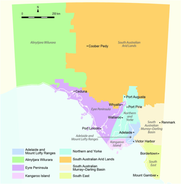
DEWNR REGIONS.
DEWNR has 8 Regions. Each of these Regions are then subdivided into Districts.
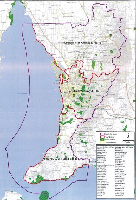
1. Adelaide and Mount Lofty Ranges
This region covers 6,581 sq km of land, 4,627 sq km of sea, and has 364 km of coastline. It supports 1.2 million people which equates to 80 % of South Australia’s population. The northern boundary of this Region incorporates the whole of the Light Regional Council, the District of Mallala and the Barossa Council. The region stretches south to Cape Jervis on the southern tip of the Fleurieu Peninusla, from the ridge of the Mount Lofty Ranges to 35 km into Gulf St Vincent. The coastline of this region encompasses the District Council of Mallala in the north to Middleton Beach in the south in the Distrct Council of Alexandrina.
There are a total of 46 parks in this region, comprising of 2 National Parks and 44 Conservation Parks.
- Adelaide & Central Hills
- Northern Hills Coasts & Plains
- Fleurieu & Willing Basin
This region covers 6,581 sq km of land, 4,627 sq km of sea, and has 364 km of coastline. It supports 1.2 million people which equates to 80 % of South Australia’s population. The northern boundary of this Region incorporates the whole of the Light Regional Council, the District of Mallala and the Barossa Council. The region stretches south to Cape Jervis on the southern tip of the Fleurieu Peninusla, from the ridge of the Mount Lofty Ranges to 35 km into Gulf St Vincent. The coastline of this region encompasses the District Council of Mallala in the north to Middleton Beach in the south in the Distrct Council of Alexandrina.
There are a total of 46 parks in this region, comprising of 2 National Parks and 44 Conservation Parks.
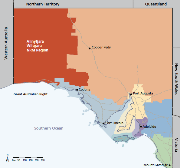
2. Alinytjara Wilurara
There are a total of 6 parks in this region, comprising of 2 National Parks, and 4 Conservation Parks in this region.
- Bunda Cliffs
- Yalata Coast
- Nullabor Plain
- Yalata Lands
- Yellabinna and Yumbarra
- Great Victoria Desert
- Southern APY
- APY Ranges
- Eastern APY and Tallaringa
There are a total of 6 parks in this region, comprising of 2 National Parks, and 4 Conservation Parks in this region.
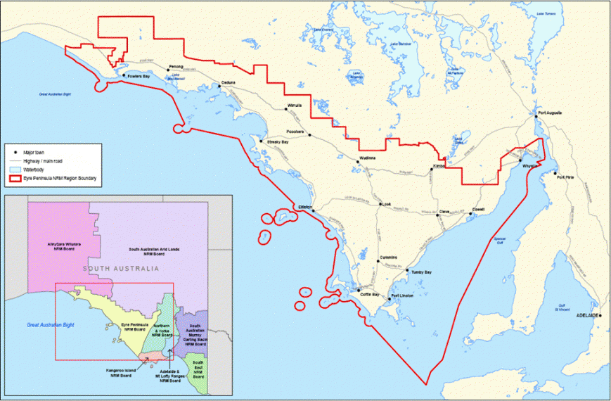
3. Eyre Peninsula
- Eyre
- Western
The Eyre Peninsula region covers an area of 80,000 square km or 8 million hectares. It includes parts of the upper Spencer Gulf, the City of Whyalla, and stretches across the southern boundaries of the Gawler Ranges, beyond Ceduna to the edge of the famous Nullabor plain, and south to Port Lincoln at the southern tip of the Eyre Peninsula.
Eyre Peninsula still has 43% of natural vegetation cover intact, making it one of the highest levels of surviving native vegetation for agricultural regions in South Australia. About 40 species of native plants are endemic to the area, with 26 plant and animal species of national conservation significance listed.
The Eyre Peninsula region includes over 1,800 km of coastline. This represents about 33% of the entire coastline of South Australia. The Eyre Peninsula NRM region contains over 100 different parks and reserves.
There are a total of 74 parks in this region, comprising of 3 National Parks, and 71 Conservation Parks.
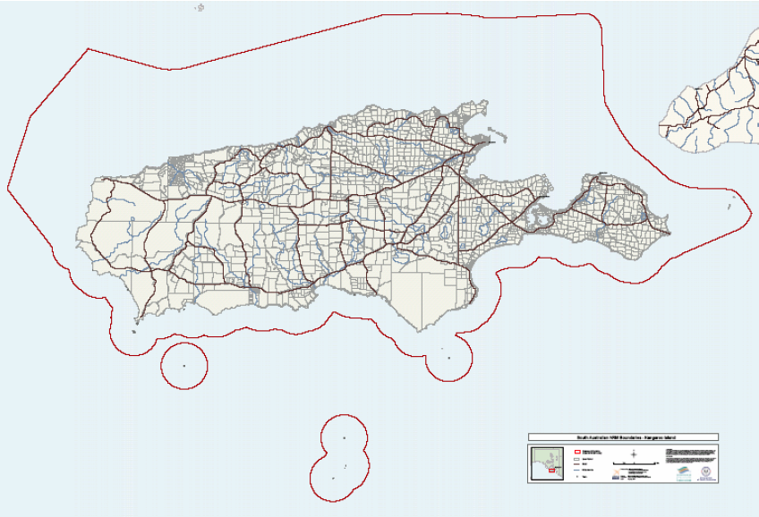
4. Kangaroo Island
The Kangaroo Island region encompasses Kangaroo Island which is about 15 km off the coastline of the southern Fleruieu Peninsula. The island covers an area of 4,370 square km. Off all the South Australian agricultural regions, Kangaroo Island contains the highest proportion of remnant vegetation. In fact, about 40% of the island is taken up by native vegetation.
The Kangaroo Island Region only contains one district. And that is Kangaroo Island.
There are a total of 22 parks in this region, comprising 1 National Park, and 21 Conservation Parks.
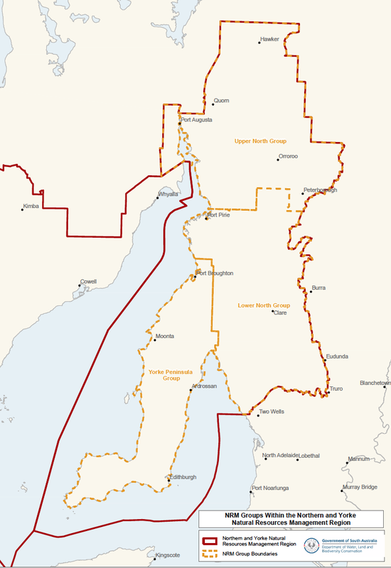
5. Northern and Yorke
The Northern and Yorke region totals 34,500 square km or more than 3 million hectares. It encompasses the Yorke Peninsula, the northern Mount Lofty Ranges, the southern Flinders Ranges, and significant areas of Spencer Gulf and Gulf St Vincent.
There are a total of 24 parks in this region, comprising of 2 National Parks, and 22 Conservation Parks.
- Yorke Peninusla Group
- Upper North Group
- Lower North Group
The Northern and Yorke region totals 34,500 square km or more than 3 million hectares. It encompasses the Yorke Peninsula, the northern Mount Lofty Ranges, the southern Flinders Ranges, and significant areas of Spencer Gulf and Gulf St Vincent.
There are a total of 24 parks in this region, comprising of 2 National Parks, and 22 Conservation Parks.
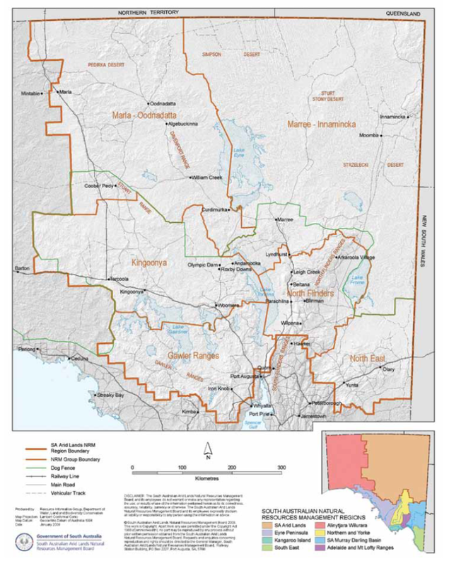
6. South Australian Arid Lands
There are a total of 15 parks in this region, comprising of 7 National Parks, and 8 Conservation Parks
- Gawler Ranges
- Kingoonya
- Marla-Oodnadatta
- Marree-Innamincka
- North Flinders
- North East
There are a total of 15 parks in this region, comprising of 7 National Parks, and 8 Conservation Parks
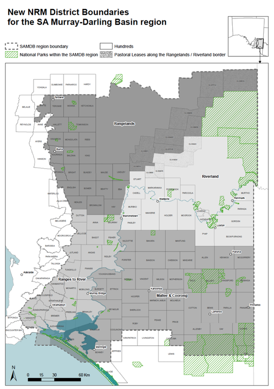
7. South Australian Murray-Darling Basin
The SA Murray-Darlling Basin region extends from where the mighty Murray River crosses the South Australian/Victorian border, down to where the Murray meets the sea at the Coorong. The region covers 70,000 square km.
There are a total of 47 parks in this region, comprising 1 National Parks, and 46 Conservation Parks.
- Rangelands
- Ranges to River
- Riverland
- Mallee & Coorong
The SA Murray-Darlling Basin region extends from where the mighty Murray River crosses the South Australian/Victorian border, down to where the Murray meets the sea at the Coorong. The region covers 70,000 square km.
There are a total of 47 parks in this region, comprising 1 National Parks, and 46 Conservation Parks.
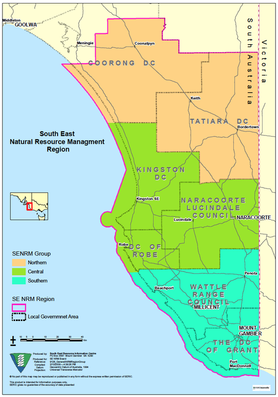
8. South East
The South East region covers an area of about 28,000 square km. It is bounded by the Victorian border to the east, the Southern Ocean to the south, and the Coorong to the west.
There are a total of 59 parks in the South East region, comprising 3 National Parks, and 56 Conservation Parks.
- Central
- Southern
- Northern
The South East region covers an area of about 28,000 square km. It is bounded by the Victorian border to the east, the Southern Ocean to the south, and the Coorong to the west.
There are a total of 59 parks in the South East region, comprising 3 National Parks, and 56 Conservation Parks.
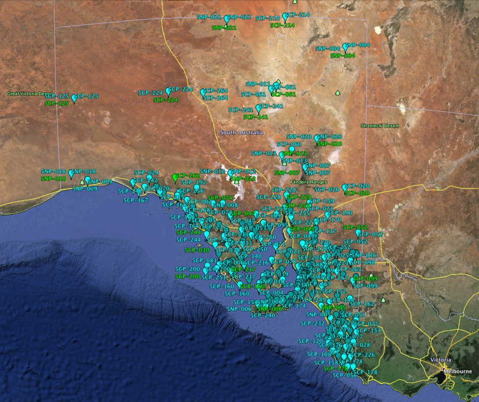
KML FILE OF SA NATIONAL & CONSERVATION PARKS
Here is a KML file which can be downloaded and used in Google Earth.
| sanpcpa-poi__1_.kml |
A HANDY MAP
Please feel free to download the PDF file below which is a map from the Department of Environment, Water & Natural Resources, showing all the Protected Areas in South Australia, including National Parks and Conservation Parks.
| protected_areas_of_south_australia_map.pdf |
DOWNLOAD A LIST OF QUALIFYING PARKS
| appendix_a_list_of_parks.pdf |
SPREADSHEET OF MATCHING 5CP CODES WITH VKFF CODES
| vk5_parks_and_vkff.pdf |
